


 다운로드 TOP50
 PC 카테고리
 자유게시판
자유게시판
onX Offroad: Trail Maps & GPS
 다운로드수 143,087
-
0 (0명)
| 분류 | 지도/내비게이션 |
|---|---|
| 버전 | 24.52.0 |
| 연령 | 3세 이상 |
| 업데이트 | 2019. 4. 11. |
| 금주 다운수 | 0 |
| 누적 다운수 | 143,087 |
| 개발사 | onXmaps |
| 다운로드 | |
|
!소프트웨어 사용범위 위반 시
법적 책임을 질 수 있습니다. |
|


상세정보
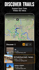
GPS mapping App that lets you easily find the offroad trails you39re looking forwhether you want to discover whats open nearby or explore somewhere new Filter 615K miles of nationwide trails by accessibility for 4x4 SxS dirt bikes moto ATV/Quads Overland and snowmobiles
Government Information
onXmaps Inc does not represent any government or political entity though you may find various links to public information within our services For more information on any government information found within the services click on the associated gov link
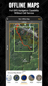
Navigate Without Cell Coverage
Save Offline Maps to bring your custom maps and adventure along when you39re outside cell coverage on the trail With the onX Offroad App you turn your phone into a handheld GPS device using your phone39s internal GPS Navigate offline by following the blue dot to always know how to get homewherever home is that night
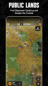
Adventure is Tap Away with Our Library of Map Data
With map data sourced from USFS MVUM BLM and NPS our colorcoded basemap includes offroad trails Public Land boundaries and recreation points to let you quickly scan for open routes near you and locate dispersed camping or campgrounds Tap anywhere on the map to find hiking trailheads trailer parking nonethanol fuel stations boat launches fishing access and more Scout the landscape and visualize mountains by viewing your maps in 3D topo satellite imagery or a hybrid
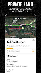
Private Property Maps With BoundariesElite Only
Make your maps Elite to discover more offroad access with private property boundaries and data for the whole country Know where you can offroad and camp and find out who owns OHV trails or the property next to a trail easement with our Private Land Map Layer
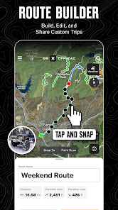
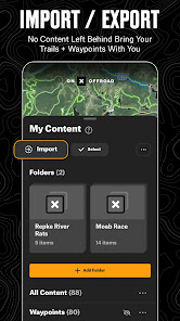
Plan Record Save and Share Your Trips
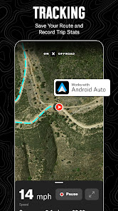
Drop Waypoints to save points of interest on your maps and share locations with others Go and Track records and saves your speed distance location and leaves a breadcrumb trail so youll always find your way back and can share your ride with friends and family
OffRoad Trails In Your Vehicles Dash
Android Auto compatibility lets you enjoy handsfree navigation and view off road trails and maps indash When in service Android users can see their indash maps in 3D
PREMIUM AND ELITE OFFROAD APP FEATURES
Private Land LayerELITE ONLY Nationwide private property maps and land boundaries ownership information and acreage
985 million acres of Public Land across the US
615000 miles of motorized roads and trails offroad for 4x4 SidebySide dirtbikes dual sport ATV Quads Overlanding and snowmobiling
24K topographic maps and 3D maps for the entire US
Designated camping areas campsites campgrounds
Hot Springs Breweries and much more
Save unlimited Offline Maps for offline navigation without cell service
Mark points along your route with photo Waypoints to plan and share your adventures
onX OFFROAD GOVERNMENT DATA SOURCES
https//datafsusdagov/geodata/
https//gbpblmegishubarcgiscom/
https//wwwarcgiscom/home/grouphtmlid00f2977287f74c79aad558708e3b6649overview
TERMS OF USE https//wwwonxmapscom/tou
Privacy Policy https//wwwonxmapscom/privacypolicy
FEEDBACK
At onX its our mission to help you find new places to explore with confidence knowing you have onX Offroad with you
If you have any trouble or have an idea on what youd like to see in the app next please contact us at supportonxmapscom Wed love to hear from you
리뷰
- 소프트쉐어 신규 소프트웨어 추가 안내 2025.01.17
- 소프트쉐어 서비스 이용 가이드 업데이트 안내 2025.01.17
- 소프트쉐어 웹사이트 리뉴얼 안내 2025.01.17


