


 다운로드 TOP50
 PC 카테고리
 자유게시판
자유게시판
US Topo Maps
 다운로드수 1,916,390
-
4.3 (0명)


| 분류 | 지도/내비게이션 |
|---|---|
| 버전 | 7.6.0 |
| 연령 | 3세 이상 |
| 업데이트 | 2013. 5. 7. |
| 금주 다운수 | 0 |
| 누적 다운수 | 1,916,390 |
| 개발사 | ATLOGIS Geoinformatics GmbH & Co. KG |
| 다운로드 | |
|
!소프트웨어 사용범위 위반 시
법적 책임을 질 수 있습니다. |
|


상세정보
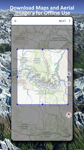
Easy to use outdoor navigation app with free access to the best available maps and aerial imagery for the USA
Choose between 30 map layers topos aerials sea charts to plan the perfect trip and
turn your Andoid Phone/Tablet into an outdoor GPS for offline trips into the backcountry
Add easily maps from other sources GeoPDF GeoTiff Online Map Services like WMS
Available basemap layers for USA
USGS National Map Topo
USGS National Map Imagery Topo
USGS National Map Imagery
USGS NAIP HiRes Imagery
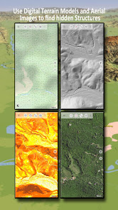
USGS Topo traditional DRGs Seamless coverage of topo maps of the USA at Scales 1250000 1100000 163000 and 124000/25000
FSTopo Forest Maps
NOAA Nautical RNC Charts
National Elevation Maps Hillshade Slope Map Aspect Map
Worldwide basemap layers
OpenStreetMaps 5 different map layouts also downloadable in space saving vectorformat
Google Maps Satellite images Road and TerrainMap
Bing Maps Satellite images RoadMap
Earth At Night
Configure a basemap layer as an overlay and utilize a transparency fader to seamlessly compare maps with each other
Add maps from other sources
Import raster maps in GeoPDF GeoTiff MBTiles or Ozi Oziexplorer OZF2 amp OZF3
Add web mapping services as WMS or WMTS/Tileserver
Import OpenStreetMaps in Vectorformat eg complete USA for just some GBs
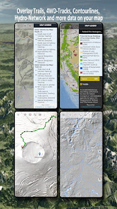
Available US map Overlays add additional information to any other base map
Public Land Ownership PADUS 3
National Hydrographic Dataset
Motor Vehicle Use Map USDA
Elevation Contourlines
4WD Trails
Trails
Roads Railroads Airports
Available worldwide overlays
Hillshading overlay
20m Contourlines
OpenSeaMap
There is no perfect map Toggle between the different map layers or use the compare maps feature to find the most interesting route Especially the old traditional DRGs contain many small pathes or other features that are missing on modern maps
Main features for outdoornavigation
Download map data for OFFLINE USAGE
Measure pathes and aereas
Create and edit Waypoints
GoToWaypointNavigation
Create and edit Routes
RouteNavigation PointtoPoint Navigation
Track Recording with speed elevation and accuracy profile
Tripmaster with fields for odometer average speed bearing elevation etc
GPX/KML/KMZ Import/Export
Search placenames POIs streets
Get elevation and distance
Customizable datafields in Map View and Tripmaster eg Speed Distance Compass
Share Waypoints Tracks or Routes via eMail Dropbox WhatsApp
Use coordinates in WGS84 UTM or MGRS/USNG Military Grid/ US National Grid
Track Replay
and many more
Use this navigation app for outdoor activities like hiking biking camping climbing riding skiing canoeing hunting snowmobile tours offroad 4WD tours or searchamprescue SAR
Add custom waypoints in longitude/latitude UTM or MGRS/USNG format with WGS84 datum
Import/Export/Share GPSWaypoints/Tracks/Routes in GPX or Google Earth KML/KMZ format
See animated NEXRAD rain radar to make accurate predictions when raining will start/stop
Please send questions comments and feature requests to supportatlogiscom
리뷰
- 소프트쉐어 신규 소프트웨어 추가 안내 2025.01.17
- 소프트쉐어 서비스 이용 가이드 업데이트 안내 2025.01.17
- 소프트쉐어 웹사이트 리뉴얼 안내 2025.01.17


