


 다운로드 TOP50
 PC 카테고리
 자유게시판
자유게시판
SailTimer™
 다운로드수 59,620
-
0 (0명)
| 분류 | 지도/내비게이션 |
|---|---|
| 버전 | 1.5.9 |
| 연령 | 3세 이상 |
| 업데이트 | 2019. 11. 25. |
| 금주 다운수 | 0 |
| 누적 다운수 | 59,620 |
| 개발사 | SailTimer Inc. |
| 다운로드 | |
|
!소프트웨어 사용범위 위반 시
법적 책임을 질 수 있습니다. |
|


상세정보
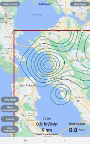
Whether you are going out fishing waterskiing sailing or crossing open water this app shows you an animation of wind direction and wind speed and contour lines of precise wind zones The app was originally designed to help sailboats navigate But now the charts and crowdsourced wind maps are useful for power boats sailboats kayaks kite surfers
The marine weather forecast comes from satellite imaging which is not very accurate and does not actually measure the wind Fortunately with years of crowdsourcing from sailboats we have growing coverage with crowdsourced wind maps In coastal areas we archive the crowdsourced wind data to map how the wind flows around islands and into channels Then even if there is not live data there at a certain time we still know how the wind will flow there
Crowdsourced maps like this have never been possible before A wind sensor tells you local wind around your boat but now you can know the wind and sea state up ahead or around the next point
App Instructions and Unique Features
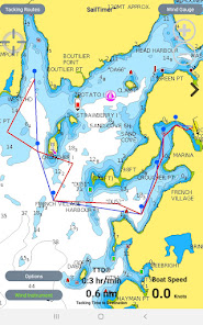
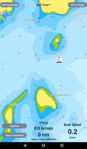
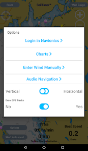
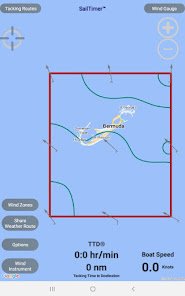
Worldwide vector charts Google Maps and aerial photos If you have the Navionics Boating app you can import your Navionics charts here with a yearly subscription
The white crosshair icon in the top left is the FollowMe button If clicked it turns blue and keeps your location in the center of the screen as you move Unselect when not moving to look around the map and when you want to zoom in and out
GPS track can be displayed under options Save a screenshot to view or share your trip later
The Wind Zones button has a small inapp subscription to see precise contour lines of wind zones or an animation showing wind direction and speed
Features for Sailboats
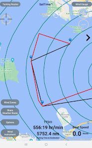
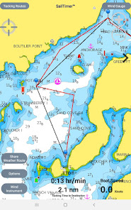
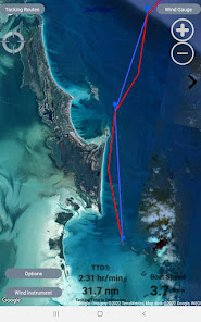
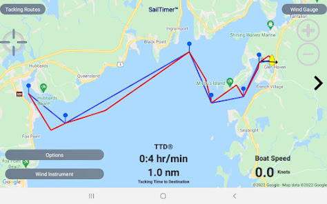
Standard GPS chartplotters and mapping apps do not account for sailboat tacking distances But if they do not know the distance you will travel how can they calculate your correct ETA SailTimer gives you a quick and easy display of your optimal tacks and TTD Tacking Time to Destination
If you have the wireless SailTimer Wind Instrument wwwSailTimerco connected to your phone/tablet your optimal tacks will update automatically in this app as the wind changes Or you can manually enter wind direction and wind speed to see your optimal tacks for the route you are planning
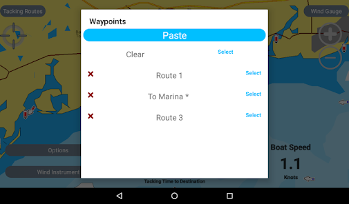
Waypoints Use the Tacking Routes button in the upper left to add new waypoints or to select from a list
Just select a route to see the optimal tacks to each waypoint For wind use the wireless SailTimer Wind Instrument https//wwwSailTimerWindcom so that your tacks update automatically as the wind changes or enter wind speed/direction manually
When you pass a waypoint press the gt on the right side of the screen to go to the next waypoint Press lt on the left side to see optimal tacks to the previous waypoint
The optimal tacks are the same headings whether you do the port or the starboard tack first See the FAQs at http//sailtimerappcom/FAQhtml for hints about avoiding obstructions by switching to the other tack
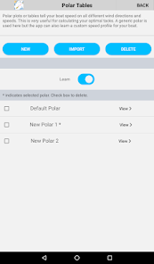
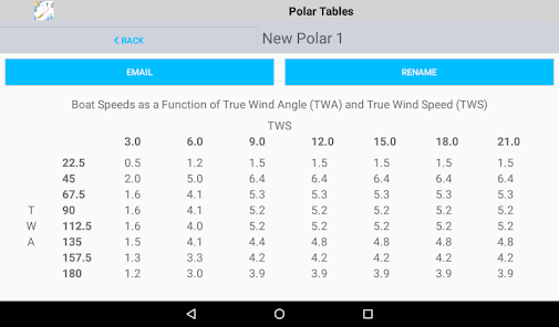
Polar plots The app comes with a default polar plot for calculating optimal tacks which you can edit Plus it can learn the custom profile for your boat39s speed on different wind angles polar plot
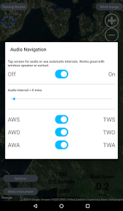
Wind gauge button in upper right when using wireless Wind Instrument shows True and Apparent Wind Angle and Direction TWD TWA AWD AWA in TrueNorth and MagneticNorth reference
Audio feedback is available by tapping screen to hear wind conditions More audio features are available in the SailTimer Wind Gauge app
License Agreement http//wwwsailtimerappcom/LicenseAgreementAndroidpdf
Navionics privacy policy and terms of use http//wwwsailtimerappcom/VectorChartshtml
For any questions SailTimer Tech Support is prompt and helpful infoSailTimerco
리뷰
- 소프트쉐어 신규 소프트웨어 추가 안내 2025.01.17
- 소프트쉐어 서비스 이용 가이드 업데이트 안내 2025.01.17
- 소프트쉐어 웹사이트 리뉴얼 안내 2025.01.17


