


 다운로드 TOP50
 PC 카테고리
 자유게시판
자유게시판
Bristol Maps
 다운로드수 141
-
0 (0명)


| 분류 | 지도/내비게이션 |
|---|---|
| 버전 | 2.25 |
| 연령 | 3세 이상 |
| 업데이트 | |
| 금주 다운수 | 0 |
| 누적 다운수 | 141 |
| 개발사 | Bygone Fisherman |
| 다운로드 | |
|
!소프트웨어 사용범위 위반 시
법적 책임을 질 수 있습니다. |
|


상세정보
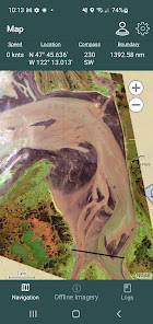
Bristol Maps is designed specifically for commercial fishermen to navigate using the latest satellite imagery Currently serving Bristol Bay and Copper River watersheds Say goodbye to outdated maps and inaccurate information our app utilizes the latest detailed images for increased efficiency safer fishing trips and a higher return on investment
Like all fishermen I have always relied on NOAA charts created for Bristol Bay Given how fast the environment changes these are out of date almost as soon as they are made In some areas there are no similarities between the NOAA charts and what exists And as exciting as it is to find the channel with the bow of your boat it is at best time consuming and at worst dangerous in the wrong weather
With this app you can view personally curated satellite images photographed at low tide I39ve found its been helpful to see where bars have moved to The core functionality allows for multiple images to be layered with transparencies to view simultaneously For areas with multiple images at varying tides it allows you to see where there will/not be water available NOAA charts are also available that allow new satellite imagery to be overlayed onto traditional familiar NOAA charts
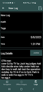
Beyond the core mapping functionality tide and weather data is also available Weather can be pinpointed to a location as well as the nearest NOAA zone weather forecast These can be combined with the mapping functionality to create digital logs Location weather and tide catch/delivery data can all be integrated into a log event Log events can be overlaid on the navigation page as well as analyzed to view catch data by species area gear type 475quot vs 5quot and weather
Feature list
Satellite overlays available for Naknek/Kvichak Egegik Ugashik Nushagak and Copper River Additional areas added by request
NOAA overlays available for Alaska while offline and all of US via online base map
Grid Layouts with search can replace traditional paper maps or code tables shared by groups IE quotI39m over by green 22quot A search tool is included to quickly find locations
NOAA tide charts available offline for Bristol Bay tide stations Other locations downloaded as they are used
Pinpoint weather forecasts available as well as NOAA zone weather forecasts
Boundary lines for all major districts are preprogrammed w/ the ability to create new boundaries Use at your own risk
A boundary alarm triggered when you are detected within X distance of the nearest boundary line
Create Waypoints and Routes These can also be exported/imported by other users to share data
Online maps can also be streamed with NOAA charts custom satellite views a high res Ak Government view and a street view if thats ever helpful
Log events can record opener times tides weather pictures sets/deliveries and district
Coming this fall a printed log book will be available for a hard copy option to have a 39seasonal39 journal
Subscription required
150 billed annually
A two week free trial is included for testing and includes free cancellation Subscription includes updates bug fixes general support and continuous imagery additions as available All that for less than a Netflix subscription
리뷰
- 소프트쉐어 신규 소프트웨어 추가 안내 2025.01.17
- 소프트쉐어 서비스 이용 가이드 업데이트 안내 2025.01.17
- 소프트쉐어 웹사이트 리뉴얼 안내 2025.01.17


