


 다운로드 TOP50
 PC 카테고리
 자유게시판
자유게시판
AvareX
 다운로드수 534
-
0 (0명)
| 분류 | 지도/내비게이션 |
|---|---|
| 버전 | 0.0.45 |
| 연령 | 3세 이상 |
| 업데이트 | |
| 금주 다운수 | 0 |
| 누적 다운수 | 534 |
| 개발사 | Apps For Aviators |
| 다운로드 | |
|
!소프트웨어 사용범위 위반 시
법적 책임을 질 수 있습니다. |
|


상세정보
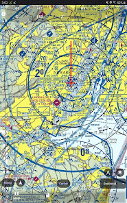
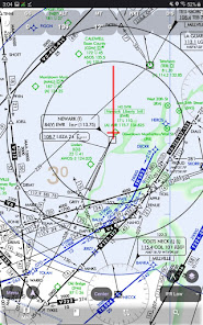
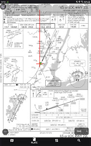
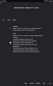
AvareX is designed for pilots and contains Georeferenced FAA Aeronautical Charts IFR High and Low VFR Sectional and TAC Flyway helicopter instrument approach plates and Chart Supplements for the United States and its territories only For charts outside of the Unites States AvareX relies on quotOSMquot or Open Street Maps AvareX supports ADSB In data from any WiFI GDL90 device eg StratuX late model StratuS iLevil etc and will display traffic weather and other ADSB received data
AvareX is completely free to use without cost paid subscription ads or sale of your personal information AvareX is a pending replacement for the original Avare application AvareX is community supported and funded through user donations
AvareX is currently in the Beta version active development stage Pilots are testing AvareX using it in flight providing feedback and submitting feature requests
We invite you to join the international Apps4Av community in further refining this amazing app Join our YouTube Channel and Google Groups Forum and help to our further refining of AvareX XCrossPlatform AvareX is the next generation of the popular legacy SinglePlatform Android only Avare app AvareX now runs on every major computing platform iOS iPhone/iPad MacOS Windows Linux ChromeOS and of course Android
Join the mailing list for tips tricks support and other help at https//groupsgooglecom/g/apps4avforum or apps4avforumgooglegroupscom
리뷰
- 소프트쉐어 신규 소프트웨어 추가 안내 2025.01.17
- 소프트쉐어 서비스 이용 가이드 업데이트 안내 2025.01.17
- 소프트쉐어 웹사이트 리뉴얼 안내 2025.01.17


