


 다운로드 TOP50
 PC 카테고리
 자유게시판
자유게시판
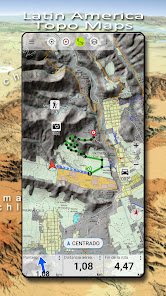
Latin America Topo Maps
 다운로드수 166,455
-
0 (0명)
| 분류 | 지도/내비게이션 |
|---|---|
| 버전 | 7.6.0 |
| 연령 | 3세 이상 |
| 업데이트 | 2012. 5. 25. |
| 금주 다운수 | 0 |
| 누적 다운수 | 166,455 |
| 개발사 | ATLOGIS Geoinformatics GmbH & Co. KG |
| 다운로드 | |
|
!소프트웨어 사용범위 위반 시
법적 책임을 질 수 있습니다. |
|


상세정보
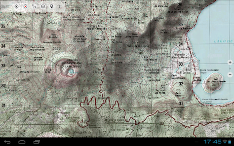
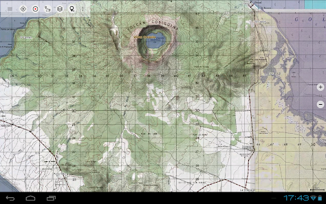
Easy to use outdoor navigation app with free access to topographic maps for most parts of Latin America
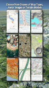
Choose between lots of map layers topogrpahic maps aerial images nautical charts to plan the perfect trip and
turn your Andoid Phone/Tablet into an outdoor GPS for offline trips into the backcountry
Note Please use OpenStreetMap Google or Bing layers if you need most recent maps
Add easily maps from other sources GeoPDF GeoTiff Online Map Services like WMS
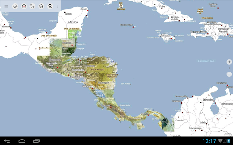
Worldwide accurate and detailed Maps
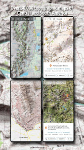
Available topographic map layers for Latin America
Mexico INEGI Maps 120000 1250000 Over 7000 maps
Brazil 125000 ca 15 150000 ca30 1100000 ca 75 1250000 ca 90
Argentina 150000 ca 30 1100000 ca 70 1250000 100
Paraguay 1100000 ca 80
Peru 125000 ca 20 150000 ca 15 1100000 100
Bolivien 1100000 ca 45
Chile 1250000 100
Guatemala 150000 100
Honduras 150000 100
El Salvador 150000 100
Nicaragua 150000 100
Belize 1250000 100
Costa Rica 1250000 100
Panama 1250000 100
Haiti 150000 100
Dominican Republic 150000 100
Worldwide basemap layers
OpenStreetMaps 5 different map layouts also downloadable in space saving vectorformat
Google Maps Satellite images Road and TerrainMap
Bing Maps Satellite images RoadMap
Waze Roads
Earth At Night
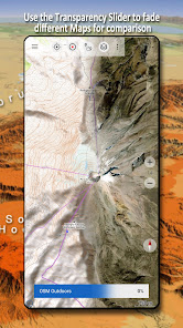
Configure a basemap layer as an overlay and utilize a transparency fader to seamlessly compare maps with each other
Add maps from other sources
Import raster maps in GeoPDF GeoTiff MBTiles or Ozi Oziexplorer OZF2 amp OZF3
Add web mapping services as WMS or WMTS/Tileserver
Import OpenStreetMaps in Vectorformat eg complete USA for just some GBs
Available worldwide overlays
Hillshading overlay
20m Contourlines
OpenSeaMap
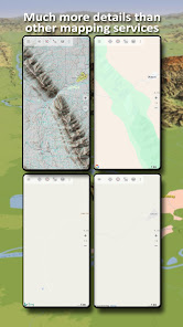
There is no perfect map Toggle between the different map layers or use the compare maps feature to find the most interesting route Especially the old topo maps contain many small pathes or other features that are missing on modern maps
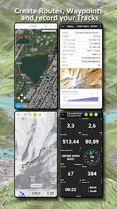
Main features for outdoornavigation
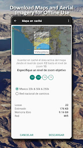
Download map data for OFFLINE USAGE
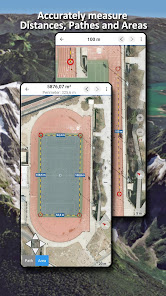
Measure pathes and aereas
Create and edit Waypoints
GoToWaypointNavigation
Create and edit Routes
RouteNavigation PointtoPoint Navigation
AutoRouting Routes calculated on OpenStreetMap data with profiles for walking bicycle or mountainbike
Track Recording with speed elevation and accuracy profile
Tripmaster with fields for odometer average speed bearing elevation etc
GPX/KML/KMZ Import/Export
Search placenames POIs streets
Get elevation and distance
Customizable datafields in Map View and Tripmaster eg Speed Distance Compass
Share Waypoints Tracks or Routes via eMail Dropbox WhatsApp
Use coordinates in WGS84 UTM or MGRS/USNG Military Grid/ US National Grid
Track Replay
and many more
Use this navigation app for outdoor activities like hiking biking camping climbing riding skiing canoeing hunting snowmobile tours offroad 4WD tours or searchamprescue SAR
Add custom waypoints in longitude/latitude UTM or MGRS/USNG format with WGS84 datum
Import/Export/Share GPSWaypoints/Tracks/Routes in GPX or Google Earth KML/KMZ format
Please send questions comments and feature requests to supportatlogiscom
리뷰
- 소프트쉐어 신규 소프트웨어 추가 안내 2025.01.17
- 소프트쉐어 서비스 이용 가이드 업데이트 안내 2025.01.17
- 소프트쉐어 웹사이트 리뉴얼 안내 2025.01.17


