


 다운로드 TOP50
 PC 카테고리
 자유게시판
자유게시판
Cartograph Maps 3
 다운로드수 1,528
-
0 (0명)


| 분류 | 지도/내비게이션 |
|---|---|
| 버전 | 3.7.2 |
| 연령 | 3세 이상 |
| 업데이트 | 2022. 1. 7. |
| 금주 다운수 | 0 |
| 누적 다운수 | 1,528 |
| 개발사 | M-Apps |
| 다운로드 | |
|
!소프트웨어 사용범위 위반 시
법적 책임을 질 수 있습니다. |
|


상세정보
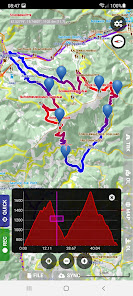
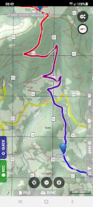
The Cartograph app views Mapsforge offline vector maps and records tracks
Please contact us if you have any questions problems or feature requests https//wwwcartographeu/v3/contact/
Map features
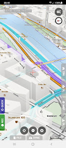
View Mapsforge offline vector maps including OpenAndroMapsorg maps
Support for OpenAndroMaps render themes Elevate Elements which are great for hiking mountainbiking running and other outdoor activities
Other supported offline map formats MBTiles raster and OpenMapTiles MVT vector TwoWays RMAP Locus SQLite Oruxmaps SQLite
Supported online map types Mapbox vector tiles MVT OpenMapTiles style Bing quadkey tile format raster OpenStreetMap slippy tile format raster raster WMS web map service including layers and styles WMTS maps
Offline hillshading and slope mapping
Mapsforge multimaps combine multiple Mapsforge maps into a single map
Classic Mapsforge and new Mapsforge VTM rendering support
Stack multiple map layers on top of each other including transparency
3D buildings
Create custom Mapsforge maps
Grid overlays including WGS84 UTM MGRS military grid reference system and many local projections
Supports classical latitude/longitude WGS84 UTM MGRS and many local proj4 coordinate display projections
Online map tile downloader see https//wwwcartographeu/v3/onlinemaptiledownloader/
Image to map calibration tool https//wwwcartographeu/v3/imagetomapcalibrationtool/
Zoom lock
Freehand drawing tool for map annotations
KML overlays including NetworkLink tags
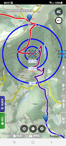
Tracks and routing
Track recording while the app is in background
Draw custom tracks using the track drawing tool
Photo video and audio waypoints
BRouter offline route calculation
OSRM routing
Google Directions Bing Routes
Basic offline navigation with voice instructions and custom audio instructions
Waypoint alerts
Current route elevation profile
Import and export gpx kml kmz only import tracks
Import EXIF JPEG photos and Google Takeout as bookmarks
Garmin icon support
Live friend tracking share your location with friends live on a map
Upload to Stravacom VeloHerocom OpenStreetMapcom custom webserver
Other features
Measurement tools distance elevation profile circular distance
Workspaces manage sets of maps/overlays/tracks
Cloud sync backup data and synchronize data among multiple devices using Microsoft OneDrive DropBox or your own web server
quotWhat39s herequot reverse geocode
Builtin offline overlays for drinking water supermarkets hostels and restaurants
Search Google Places Bing Nominatim
Search tracks Strava OpenStreetMap custom web server
Supports WunderLINQ https//blackboxembeddedcom/ and CarpeIterControl https//carpeitercom/carpeitercontrol/
Included translations English German Hungarian Polish Traditional Chinese
Create your own translations https//wwwcartographeu/v3/addons/translations/
Items marked with are available in the full version which is available as an inapppurchase
Items marked with require credits which can be obtained in the app
In app purchases
The Cartograph app offers inapppurchases for activating all features and for accessing 3rd party services such as Google Directions
A detailed description of all products is available here https//wwwcartographeu/v3/inapppurchaseinfo/
Disclaimer
The Cartograph app allows you to record your location quottrack recordingquot while the app is in background Location services can significantly increase battery usage
리뷰
- 소프트쉐어 신규 소프트웨어 추가 안내 2025.01.17
- 소프트쉐어 서비스 이용 가이드 업데이트 안내 2025.01.17
- 소프트쉐어 웹사이트 리뉴얼 안내 2025.01.17


