


 다운로드 TOP50
 PC 카테고리
 자유게시판
자유게시판
OpenGround Data Collector
 다운로드수 1,325
-
0 (0명)
| 분류 | 비즈니스 |
|---|---|
| 버전 | 10.3.7.358 |
| 연령 | 3세 이상 |
| 업데이트 | 2020. 9. 30. |
| 금주 다운수 | 0 |
| 누적 다운수 | 1,325 |
| 개발사 | Bentley Systems Incorporated |
| 다운로드 | |
|
!소프트웨어 사용범위 위반 시
법적 책임을 질 수 있습니다. |
|


상세정보
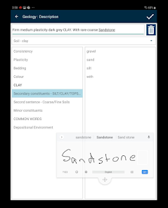
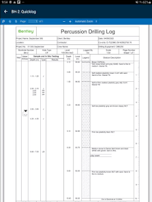
Designed for the Field Intuitive touchfriendly interface designed for use by engineers and drillers throughout the ground investigation process Typing and screen clicks are minimized via the use of autofocus picklists custom actions and configurable workflows Coordinate multiple crews provide rapid access to data from multiple locations and increase collaboration across both field and officebased teams
Streamlined Data Synchronization Simple data transfer enables data to be synchronized to the cloud in a matter of minutes eliminating the need for complex data transfer mappings while also providing full support for offline working Significantly reduce the time taken to transfer data back to the office to accelerate data analysis and report production Make data informed decisions while field teams are still on site
Customizable Data Entry Profiles Only capture the required data by utilizing Mobile Data Entry Profiles optimized for specific data collection activities including Cable percussion Trial pitting Rotary coring Insitu testing and Monitoring A single field solution to meet both geotechnical and geoenvironmental project requirements Powerful expressionbased calculated fields and default values help avoid data duplication and significantly reduce data entry time Deploy data entry profiles into cloudbased configuration packs to enable standardization across multiple projects and distributed teams
Powerful Data Validation Avoid costly data errors or incomplete data capture Configurable data quality checks and validation rules ensure high quality standards compliant data collection at source Significantly reduce data entry issues with customizable data warnings and critical checks
Automated Label Printing Streamline sample management in the field with builtin barcode generation and automated label printing via a ruggedized mobile printer
GPS and Camera Integration Quickly position exploratory locations using integrated GPS Devicebased camera integration provides automated photo linkage and synchronization including for locations soil samples and core runs
리뷰
- 소프트쉐어 신규 소프트웨어 추가 안내 2025.01.17
- 소프트쉐어 서비스 이용 가이드 업데이트 안내 2025.01.17
- 소프트쉐어 웹사이트 리뉴얼 안내 2025.01.17


