


 다운로드 TOP50
 PC 카테고리
 자유게시판
자유게시판
New Zealand Topo Maps
 다운로드수 45
-
0 (0명)

| 분류 | 지도/내비게이션 |
|---|---|
| 버전 | 7.5.1 |
| 연령 | 3세 이상 |
| 업데이트 | 2012. 1. 31. |
| 금주 다운수 | 0 |
| 누적 다운수 | 45 |
| 개발사 | ATLOGIS Geoinformatics GmbH & Co. KG |
| 다운로드 | |
|
!소프트웨어 사용범위 위반 시
법적 책임을 질 수 있습니다. |
|


상세정보
Easy to use outdoor navigation app with most recent topographic maps of New Zealand Cook Islands and Tokelau
This app gives you similar mapping options as you might know from Garmin or Magellan GPS handhelds
Main features for outdoornavigation
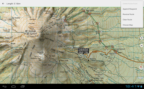
Create and edit Waypoints
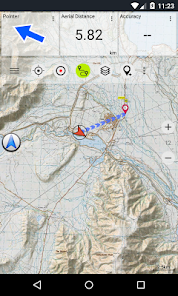
GoToWaypointNavigation
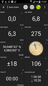
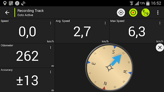
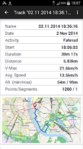
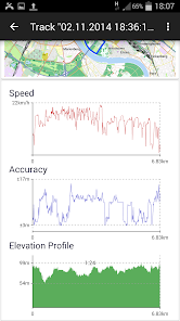
Track Recording with speed elevation and accuracy profile
Tripmaster with fields for odometer average speed bearing elevation etc
GPXImport / Export KMLExport
Search placenames POIs streets
Customizable datafields in Map View and Tripmaster eg Speed Distance Compass
Share Waypoints Tracks or Routes via eMail Facebook
Use Coordinates in UTM WGS84 or MGRS
and many more
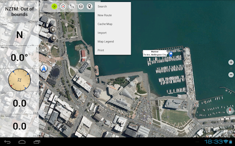
Available base map layers
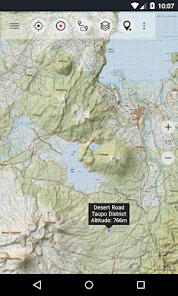
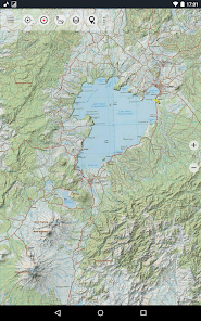
Topomaps New Zealand seamless coverage at scales 1250000 and 150000
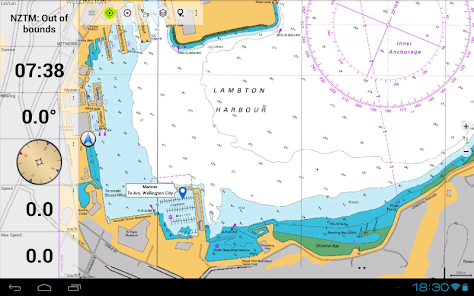
NZMariner RNC Nautical Charts
LINZ Aerial Imagery
Google Maps Satellite images Road and TerrainMap
Open Street Maps
Bing Maps
ESRI Maps
Overlay layers
Public Conservation Areas
Open Hunting Areas
DOC Camp Sites
DOC Freedom Camping Restrictions
DOC Huts
DOC TRacks
Taupo Trout Fishing District
Hillshading
Use this navigation app for outdoor activities like hiking biking camping climbing riding skiing canoeing or offroad 4WD tours
Preload FREE map data for areas without cell service Pro version only
LIMITATIONS OF THE FREE VERSION
Ads
Max 3 Waypoints
Max 3 Tracks
No Routes
No import of waypoints and tracks
No Bulkdownload
No Local City DB Offline Search
The topographic maps were created by Land Information New Zealand LINZ
Topo50 is the official topographic map series used by New Zealand emergency services
How topographic information is used
Defence planning New Zealand39s defence forces use topographic information for planning military exercises and swapping information with international partners
Location and routing Search and Rescue defence ambulance fire service police and civil defence agencies use topographic information in a wide range of planning and operational situations from natural disasters to community policing Usage may involve mobile/field and control room situations and the combination of topographic information with other data
Land management Topographic information is used by local government for regional planning and operations and by power gas and telecommunications companies
In addition LINZ maps are used for a great variety of purposes by businesses and government departments such as the Department of Conservation and by recreational users such as trampers and tourists
All topographic maps have additional labels for better readability at higher zoom scales Maps are rendered with Atlogis hillshading to enhance topography
Topo Map Coverage
New Zealand and Islands Antipodes Auckland Bounty Campbell Chatham Kermadec Raoul Snares and Stewart Islands at scale 150000 and 1250000
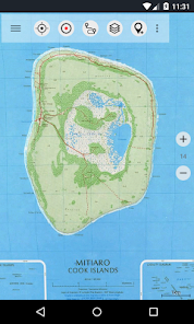
Cook Islands Aitutaki Atiu Mangaia Manihiki Mauke Mitiaro Palmerston Penrhyn Pukapuka Rakahanga Rarotonga Suwarrow Takute at scale 125000
Tokelau Islands Atafu Nukunonu Fakaofo at scale 125000
Please send comments and feature requests to nzmapsatlogiscom
리뷰
- 소프트쉐어 신규 소프트웨어 추가 안내 2025.01.17
- 소프트쉐어 서비스 이용 가이드 업데이트 안내 2025.01.17
- 소프트쉐어 웹사이트 리뉴얼 안내 2025.01.17


